The 19-person committee created to outline how to spend Acadiana's share of federal flooding and drainage aid met for the first time Tuesday and embraced a regional approach to flood management.

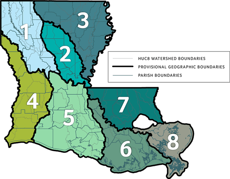
A map of regional watershed districts that will be used the Louisiana Watershed Initiative to guide the spending of a $1.2 billion federal grant.
The Louisiana Watershed Initiative is responsible for overseeing how the state spends $1.2 billion in federal disaster relief funds, which it is orchestrating through eight regional steering committees. The Region 5 committee met Tuesday in Lafayette and encompasses all of Acadiana and several surrounding parishes.
Members of the newly formed committee were quick to commit to the initiative's regional approach to prioritizing funding for flooding and drainage projects, but little action was taken to identify projects or priorities worth emphasizing.
“Trying to address those problems locally is a problem for a reason, so I’m really glad we’re starting to look at drainage problems on a regional basis,” St. Landry Parish engineer Kyle Aucoin said.
“I’m optimistic that this will be a resounding success and something that the state has long needed,” St. Martin Parish President Chester Cedars said.
“We all know that water doesn’t really care about geographical boundaries,” Pointe Coupee Parish Administration Director Mark Ward said, “so I think this is an exciting time in Louisiana to come up with solutions that are going to work 20 and 30 years down the road.”
Currently, the state is in negotiations with HDR, a national contractor, to create a floodplain model that would consider current conditions across the region’s 16 parishes and simulate the impact proposed projects or regulation changes would have on flooding in the region.
That modeling is expected to cost as much as $20 million for Region 5 and would allow every local parish, city and town access to model predictions so they can gauge the impact of future projects before breaking ground on them.
Garland Pennison, a senior project engineer for HDR, said Acadiana’s region was probably the most complex region to model in the state. He said a model would ultimately be able to predict the impact individual drainage projects would have across the region.
“We’re creating a numerical model that allows you to put in a detention pond, channelization, dredge the Vermilion (River), build a pump station, then this has nature saying this is what happens,” Pennison said.
“At the end of the day, we’re giving you a model that you have to be able to run,” he added.
About $610 million of the $1.2 billion in federal aid has to be spent to benefit 10 parishes that were highly impacted in the 2016 flood. Those include Lafayette, Acadia, Vermilion, Ouchita, East Baton Rouge, Livingston, Ascension, Tangipahoa, Washington and St. Tammany parishes.
Nicolette Jones, who is coordinating all of the state’s eight regional steering committees, said Tuesday’s meeting was the first in the state and praised the guidance of the Acadiana Planning Commission, which has pushed the committee to be weeks ahead of the rest of the state.
The steering committees are tasked with determining a list of potential projects across their regions, looking into local regulations that could help the region’s floodplain, like detention and retention pond requirements, and establishing a subsequent permanent group to oversee projects once the steering committees disband after about a year.
Acadiana’s regional steering committee encompasses 16 parishes that stretch as far north as Rapides and as far west as Cameron. The region’s boundaries are defined by the area’s four watersheds, which run south from the Red River in Rapides Parish down to the Gulf of Mexico and spread west from the Atchafalaya River Basin to the Mermentau River watershed and Lake Arthur in Cameron Parish.